Data collection of rural water supply systems
The original version of this document is located at https://docs.qfield.org/success-stories/rwanda-rural-water
Data collection by QGIS/QField for O&M work of rural water supply systems in Rwanda
By Rural Water and Sanitation Services Department(RWSS), Water and
Sanitation Corporation (WASAC), Rwanda
Goal
To conduct data collection of all rural water supply network in Rwanda,
and keep updating the data continuously in order to improve operation &
maintenance of waterworks.
Project preparation
Before starting our data collection, we conducted the following things.
: - Develop our own PostGIS database
- Develop QGIS project template with Geopackage. The Geopackage
table design is equal to PostGIS to be able to copy and paste to
PostGIS.
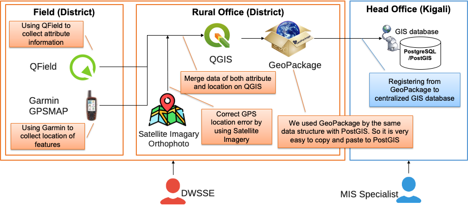
Apart from preparing Android devices, we purchased GPS devices for
higher positioning accuracy. In WASAC, we bought Garmin GPSMAP 64S.
Sometimes, GPS of smartphone and tablet is not very accurate, so we
normally capture the same location by using Garmin GPS, then correct the
location of QField's data after data collection work.
Data collection
Once we prepared GeoPackage and QGIS project template, we conducted
training of QGIS/QField in July 2018 and launched our data collection
work in 27 districts in the whole country of Rwanda.
27 engineers sent their GeoPackage to the central office in Kigali. the MIS (Management Information System) specialist validated and entered their data from GeoPackage to PostGIS database.
We completed our initial data collection works until April 2019.
Data distribution and updating
The most significant thing after data collection is updating. We have
seen many organization in Africa, which failed to keep data up to date.
Several years later, their data will normally become too old, and most
of them need to put efforts on data collection again.
WASAC decided to continuously update all of the data and keeps doing
this until now. QField has proven to be very well suited for this
purpose.
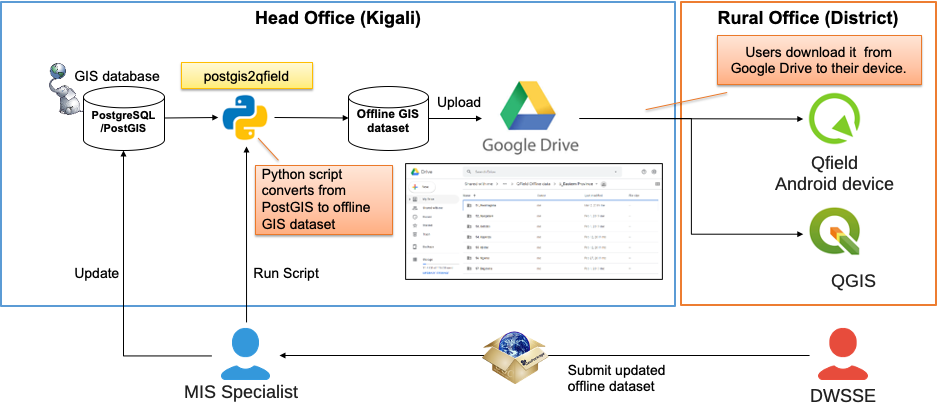
In order to distribute and updating the data, we developed a python
script postgis2qfield. This
postgis2qfield tool can extract the data from PostGIS and create GeoPackage for each district in Rwanda.
We upload these 27 GeoPackage together with QGIS project template to Google Drive storage.
After that, those engineers in districts download their GeoPackage to Android device to continue adding and updating the data.
Once they completed updating, they sent the GeoPackage to central office again, MIS specialist update PostGIS database and regenerate GeoPackage for QField.
Data sharing via vectortiles
First of all, you can see our collected data from
here.
Since July 2020, we started to distribute our water supply systems'
data via vectortiles as open data. Although Rwanda's internet situation
is being improved, some rural area still have problems of internet. In
such as poor internet situation, WMS or WFS data distribution will not
work well. Vectortiles can provide light and fast distribution of map
data. We will not talk about our vectortiles here. If you are fascinated
by how to share the result of data collection, please also see this
instruction.
Acknowledgement
We thank all of district water and sanitation support engineers to
conduct their data collection work. Additionally, we want to thank the
developers of QField and QGIS for offering fantastic open source
software. It is great that, due to free software, such projects can be
implemented by an organization of water sector in developing countries.
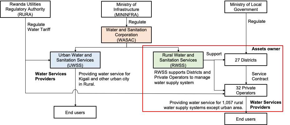
About WASAC
WASAC has 2 main departments for urban water(UWSS) and rural
water(RWSS). We are using QField in RWSS. The role of RWSS department is
to support local government to operate and maintain their owned water
supply systems in rural area. Nowadays, these data collected and
maintained by RWSS department are being used by more than 30 private
operators in 27 districts. Total number of water supply systems in the
database is 1,000+.
Also, one of our colleagues presented WASAC's activity in FOSS4G 2019
Bucharest. Although some of system were little bit changed now, you can
also see
video
if you are interested.
Related Articles
Data collection of malaria transmitting mosquitoes
The original version of this document is located at https://docs.qfield.org/success-stories/mosquito-malario-ground-truth-data-collection Use of Qfield in the context of ground-truth data collection work of malaria transmitting mosquitoes By Paul ...Ground Truth Data Collection
The original version of this document is located at https://docs.qfield.org/success-stories/lulc-mapping-fiji Ground Truth Data Collection Using QField for LULC Mapping in Fiji By Kevin Davies, School of Geosciences, The University of Sydney Purpose ...EXIF data
The original version of this document is located at https://docs.qfield.org/reference/exif EXIF Data in QField When using the internal QField camera, images will be geotagged with various EXIF metadata fields. Below is a reference table listing the ...Supported data formats
The original version of this document is located at https://docs.qfield.org/reference/data-format Supported Data Formats QField supports a wide variety of formats via QGIS data providers and GDAL. This page offers a non-exhaustive list of supported ...Data Source and project paths
The original version of this document is located at https://docs.qfield.org/how-to/project-setup/data_source_and_project_paths Data Source & project paths You can save and store your projects and layers in multiple ways and formats. It is common best ...