River State Survey
The original version of this document is located at https://docs.qfield.org/success-stories/river-state-survey
River State Survey Using QField
Goal
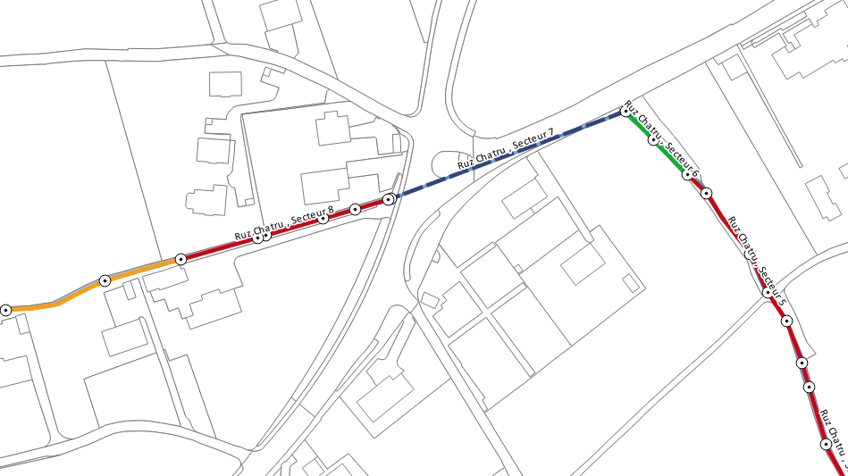
In order to assess the structural and morphological state of their water
courses, the community of Milvignes needed to survey all the rivers
crossing their territory.
Project
To facilitate the technician’s field work (usually done with a map, a
notebook and a camera), a QField project was created and made available
on a Tablet. Cadastral and river layers were used as basemap.
The structure of the input tables was designed along with the technician
to assure that it would fit their field requirements. The idea was to
have two tables:
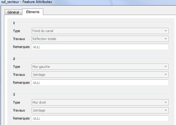
Sector table
: To draw sectors alongside the rivers and add information about their
state and structure. If necessary, pre-defined structural work on
the sector elements (wall, bridge, bottom of the canal) could also
be documented.
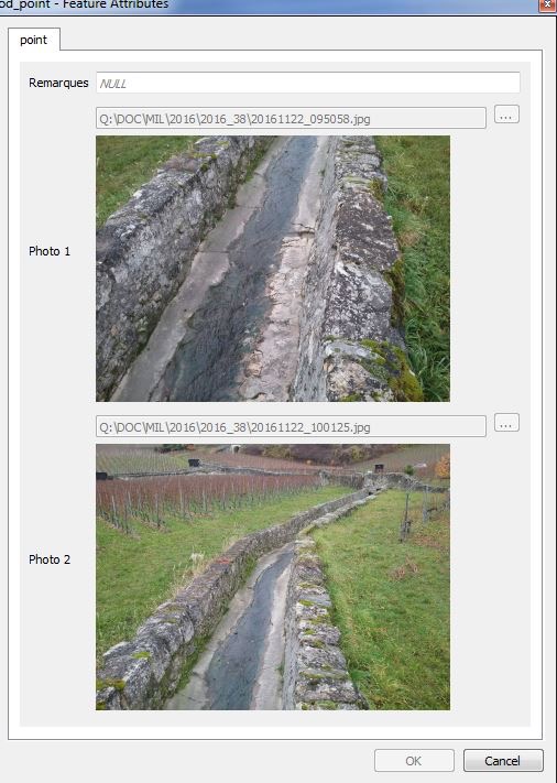
Point table
: To take punctual photography of the water courses and of its
elements and where necessary add remarks.
Result
In less than 3 days, the technician surveyed successfully all the 10‘894
meters of water courses. Back at the office, it took only 2 hours to
treat the data and get the final result.
- Facilitated the field survey
- Accelerated the data treatment
Related Articles
Vanilla Surveys
The original version of this document is located at https://docs.qfield.org/success-stories/vanilla-survey Vanilla Surveys using QField By Ahi Saipaia[^1], Leody Vainikolo[^1], and John Duncan[^2] [^3] [^1]: Ministry of Agriculture, Forestry, Food, ...Heritage Impact Assessment
The original version of this document is located at https://docs.qfield.org/success-stories/heritage-impact-assessment Heritage Impact Assessment using QField From QGIS to QField and Vice Versa: How the New Android Application Is Facilitating the ...XLSForm Converter
The original version of this document is located at https://docs.qfield.org/how-to/advanced-how-tos/xlsforms-plugin XLSForm Converter Plugin for QGIS Use the XLSForm Converter plugin to convert existing XLSForms into QGIS projects. This tool migrates ...Mapping breeding birds
The original version of this document is located at https://docs.qfield.org/success-stories/mapping-breeding-birds-in-the-Wadden-Sea Use of QField for mapping breeding birds in the Wadden Sea By Benjamin Gnep, Schutzstation Wattenmeer e.V. 29.07.2019 ...Project creation in QFieldCloud
The original version of this document is located at https://docs.qfield.org/get-started/tutorials/create-project-qfc Creating Projects in QFieldCloud There are multiple options available to initialize and build a project in QFieldCloud: Using QGIS ...