Live default value
The original version of this document is located at https://docs.qfield.org/how-to/advanced-how-tos/live-default-value
Live default value
QField is supporting the “live” updating of default attribute value when editing features.
This means, when changing one value in an attribute another automatically adjusts.
Examples for this could be species names that are both recorded with the original species name and the common name.
Workflow
Configuration
🖥️ Desktop preparation
In this example, the image will automatically update when a different plant_species is chosen.
- Direct to the layer properties, where you want to set the updating value field.
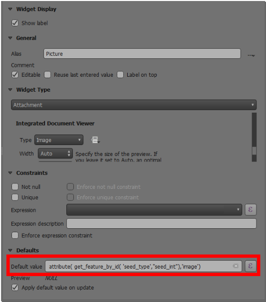
- Go to the ‘photos’ field and add the following expression into the default value.
-
Toggle the apply default upon update.
-
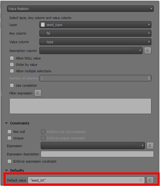
Go to the plant_species field where your value relation is set as a widget type.
-
Add the following expression as shown below into the default value.
-
Press Ok and save.
Example
In the video below there is an example of “live” default value updates when editing features on QField.
Related Articles
Attachment widget
The original version of this document is located at https://docs.qfield.org/how-to/project-setup/pictures Use attachment In QField, a field with Attachment widget can be used to: Show and take photos Show and record videos Listen and record sound ...All about GPS, GNSS and NTRIP
The original version of this document is located at https://docs.qfield.org/how-to/navigation-and-positioning/gnss Positioning (GNSS) QField is capable to show your live position using several sources: Either by using the internal GNSS (Global ...Processing algorithms
The original version of this document is located at https://docs.qfield.org/how-to/data-collection/processing Processing Algorithms QField offers access to a number of processing algorithms to modify digitized features and their geometries. Showing ...External routing
The original version of this document is located at https://docs.qfield.org/how-to/navigation-and-positioning/external-routing External routing It can come in handy to calculate an itinerary to one of your features in the field. By an easy ...Simple attribute form configuration
The original version of this document is located at https://docs.qfield.org/how-to/project-setup/attributes-form Attribute form Before you go into the field, you will have to configure your forms - the fields that the user will see in the fields. You ...