Advanced setup
The original version of this document is located at https://docs.qfield.org/get-started/tutorials/advanced-setup-qfc
Advanced setup guide
Supported vector providers
Currently, QFieldCloud supports GeoPackage and PostGIS layers for collaborative editing.
Other formats supported by QGIS should also work but are not officially supported.
Synchronization process
When working with QFieldCloud it is important that you understand the synchronization process so that you avoid data loss or the overwriting of files / deltas (changes).
You can find the technical details on the different job types in the technical documentation section.
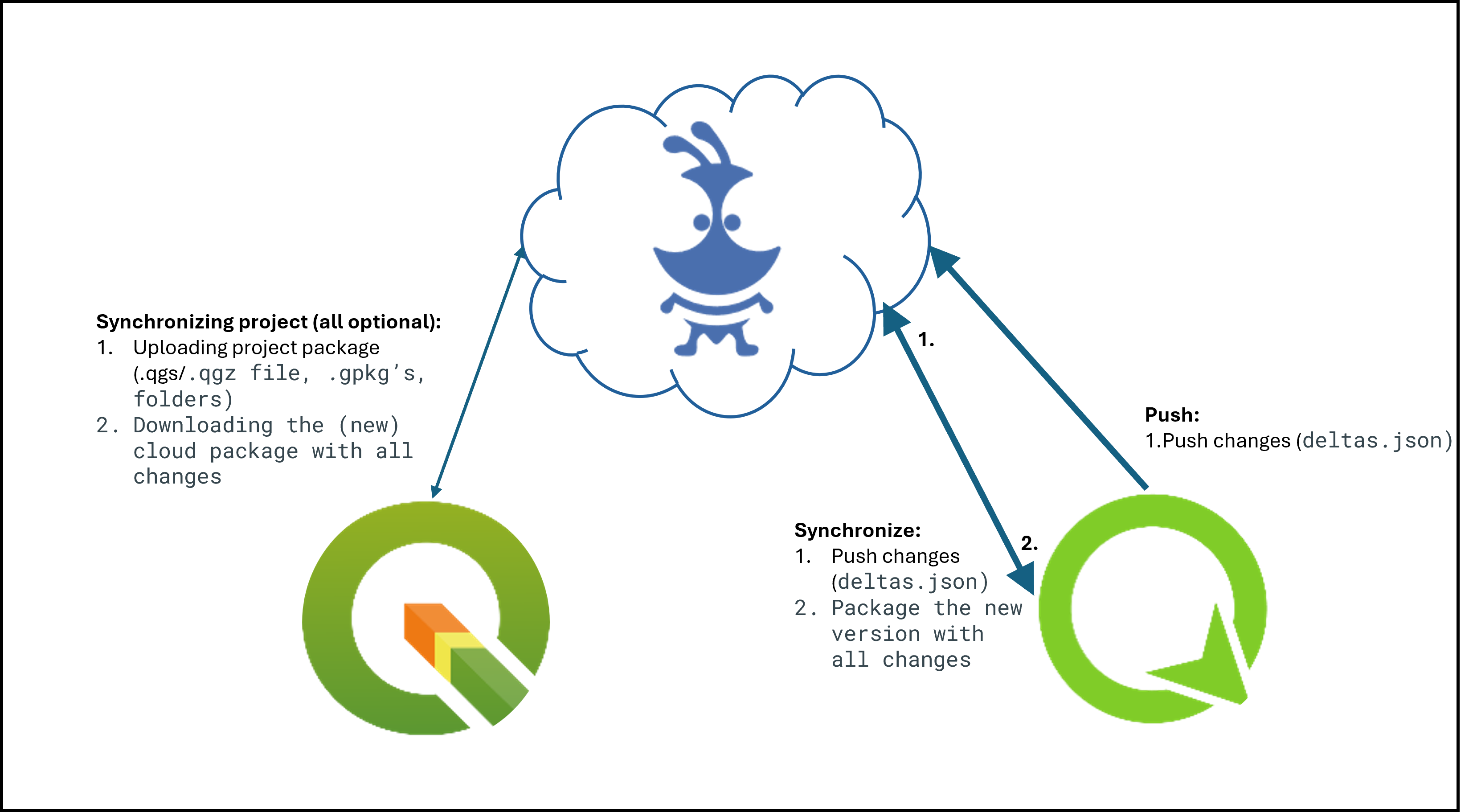
In simple words, there exist three different synchronization activities:
- From QGIS to QFieldCloud: This synchronization process uploads a complete new “project package” and replaces the existing one stored in the cloud.
If you are working with GeoPackages it is important to note, that the existing GeoPackage on the cloud will be replaced with the one you have just uploaded. - From QFieldCloud to QField: If you want to download the uploaded “project package” to your mobile device,
QFieldCloud “packages” the project into a specific format that is saved in the internal application folder structure.
Important to know here is that in case you are working with PostgreSQL databases and have chosen the working mode offline editing then a local
GeoPackage of the data will be created in the corresponding folder
(make sure to configure your secret properly), unless a direct connection is needed. - From QField to QFieldCLoud: Once you are done with collecting data, you can choose among two different synchronization options.
The changes made are being applied as so-called deltas.
Deltas reflect only the changes made to the different attributes.
When pushing to or synchronizing with QFieldCloud, it is only the deltas that are being applied.
Unlike in the synchronization process from QGIS to QFieldCloud, the whole GeoPackage is NOT replaced.
Tip
There are a few tips, which we recommend to follow in order to avoid synchronization issues or overwritten data.
- Do not modify the QGIS project while personnel is working simultaneously in QField.
If you synchronize your Desktop version to the cloud, QFieldCloud will overwrite the files.
Although there may have been changes applied in QFieldCloud, QFieldSync will not show this by default.
If you must work parallel on Desktop, make sure to check the QFieldCloud status and download the most recent data before uploading new files versions from your Desktop. - Do not change the data structure before synchronizing the latest field edits.
Often, officers work in QGIS and adapt the data structure of the project files, which leads to errors if the changes from QField have not yet been pushed to QFieldCloud. - Use uuid’s as primary keys, especially when working with relations and in teams.
Synchronization often occur due to the lack of adding primary keys to your datasets.
Especially, when working with relationships and in teams, if the data were not configured with an according primary key, it may happen that data loss occurs because of simultaneous editing of the data.
Working Modes
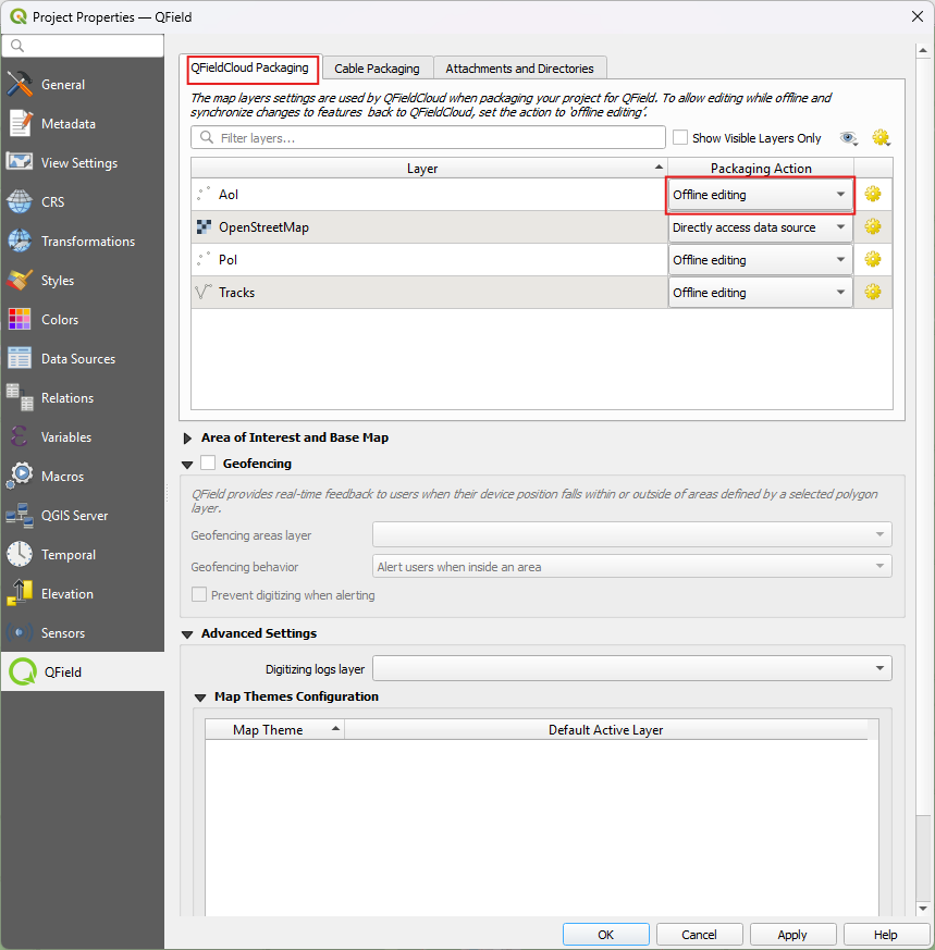
When configuring a project for QField you can choose between the different “Packaging” options.
-
Offline editing: Regardless of whether your files are stored in a GeoPackage, database or other format, QFieldCloud will create a temporary GeoPackage of all the project data.
Changes made to this GeoPackage will not be available to others.
Once the changes are synchronized or pushed back to QFieldCloud, the made changes only will be applied to the existing file on QFieldCloud.
We recommend to use this option to avoid unnecessary data losses in case of lost data connection. -
Direct Data Access: When using
direct database access, QFieldCloud will directly edit data in the PostGIS database.
This will only work with a reliable internet connection in the field, but has the advantage that all data is directly visible to all users and allows to use any PostGIS specific setup (triggers, generated fields, etc).
Changes will only be visible to users once the Synchronization via QFieldCloud has been applied on the different devices.
When a local copy is created, advanced PostGIS operations (like triggers) will not be available on QField.
You can find more information on QFieldCloud technical reference.
Working with GeoPackages
Using GeoPackages is usually the best choice for a simple setup to centralize data collected by your QField users to one single file.
If you would like to set up a relation, add a UUID field and use that as the primary or foreign key.
Note: Do not use the default fid field for relations (as primary or foreign key).
Why? The fid field can be synchronized when working with QFieldCloud and will lead to errors over time.
A UUID, on the other hand, is unique and will not be synchronized.
Workflow
🖥️ Desktop preparation
- Create a new project in QGIS.
- Create GeoPackage layers, save it in the same folder as your QGIS project.
- Set the GeoPackage to “Offline editing” in the settings of the QFieldSync plugin.
- Upload the project to QFieldCloud.
📱 Fieldwork
- Sign in to QFieldCloud and download the project to your device.
- Collect and edit some data and upload the changes.
🖥️ Desktop
- Using QFieldSync, download the updated files (the GeoPackage file should have changed).
Warning
We do not recommend to edit or add new data from QGIS directly because everytime QGIS synchronizes the project to QFieldCloud the whole GeoPackage replaces the existing on QFieldCloud, whereas when using QField, only the actual changes within the file will be updated.
PostGIS
Using PostGIS is a good choice if your data should be visible and editable for multiple users.
It requires your database to be publicly accessible, and credentials must be saved unencrypted in the QGIS project.
Please be aware of the security implications of such requirements, and remember to have backups.
There are two possible ways, in which the access to the database can be saved and made available for QFieldCloud.
- Direct Connection: When connecting to a PostGIS database, you can store all information including the credentials inside the QGIS Project directly.
- Using a PG Service File: Using a service file that can be saved as a “secret” in QFieldCloud.
We highly recommend to make use of this option due to data safety.
Read more on PG Service and Secrets here
Workflow
🖥️ Desktop preparation
- Create a new project.
- Add a PostGIS layer, making sure to store the credentials in the project or having created the PG Service file.
- Make sure the PostGIS database connection is publicly accessible (public IP or domain name, it will not work with
127.0.0.1orlocalhost). - In the QFieldSync project settings, choose your preferred packaging mode.
- Upload the project to QFieldCloud.
📱 Fieldwork
- Sign in to QFieldCloud and download the project.
- Collect some data
- Push or synchronize the changes once back at the office if you were using
offline editing.
🖥️ Desktop
- All changes should be directly visible inside the PostGIS database.
Note
When using direct database access, QFieldCloud will directly edit data in the PostGIS database.
This will only work with a reliable internet connection in the field, but has the advantage that all data is directly visible to all users and allows to use any PostGIS specific setup (triggers, generated fields, etc).
Note
When using offline editing, QField will work on a local copy of the database in a GeoPackage, which will be synced by QFieldCloud to the original database once synchronized by the user.
We recommend to use this option to avoid unnecessary data losses in case of lost data connection.
Changes will only be visible to users once the Synchronisation via QFieldCloud has been applied on the different devices.
When a local copy is created, advanced PostGIS operations (like triggers) will not be available on QField.
You can find more information on QFieldCloud technical reference.
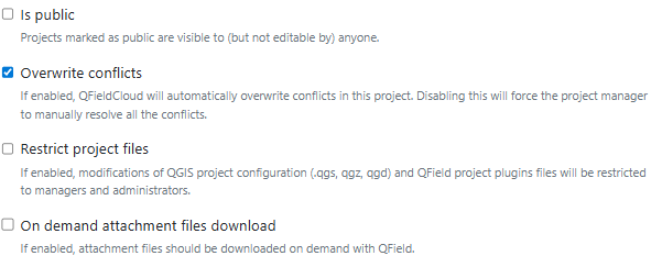
Restriction of Project Files
To prevent any modification to the core QGIS project file, the project administrators can restrict the access to these files.
This can be achieved under the settings section in QFieldCloud.
- From the QFieldCloud homepage direct to Settings
- Enable the
Restrict project filesbutton
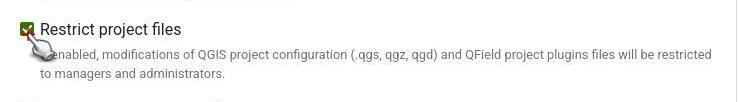
Once set, only administrators and managers will be able to push changes to the files listed above.
Other project collaborators can still upload and modify other project files, such as data in GeoPackages, but they cannot alter the main project file or its core components.
Restricted Files
When enabled, the following files can only be modified or uploaded by a user with an “admin” or “manager” role for the project:
- The primary QGIS project file (e.g.,
my_project.qgz). - The attachments zip archive associated with the project (e.g.,
my_project_attachments.zip). - QGIS auxiliary data files that store information like label positions (e.g.,
my_project.qgd). - QField style files (
.qml) that share the same name as the project file.
Handling Conflicts
When working in a collaborative environment with many users accessing the same project, it may happen that two users modify the same object during a mapping session.
In your settings page, you can choose whether QFieldCloud should apply the last wins policy or whether conflicts should be marked and handled by a project manager.
See more on how QFieldCloud handles conflicts here
Activate email notifications for QFieldCloud changes
If you wish to be notified by QFieldCloud what happens to your team(s) and your projects, you can activate the email notification option.
- On your QFieldCloud landing page direct to settings.
- Navigate to the notifications section.
Here, you can customize the frequency of notifications you wish to receive at the email address registered with your account.
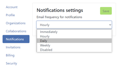
The events you get notified about are:
- User created
- Organization created
- Organization deleted
- Organization membership created
- Organization membership deleted
- Team created
- Team deleted
- Team membership created
- Team membership deleted
- Project created
- Project deleted
- Project membership created
- Project membership deleted
You will receive notifications for events in which you are not the actor.
These notifications are specifically for events that are initiated by other members of your organization or collaborators on your projects.
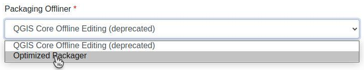
Enhance your project with the “Optimized Packager”
We recommend using the new “Optimized Packager” over the deprecated “QGIS Core Offline Editing” for all your projects.
Explanation
Unlike the “QGIS Core Offline Editing” packager the “Optimized Packager” consolidates filtered layers of same datasource into a single offline layer, respecting the distinct symbology but also using less storage.
What does this actually mean: If you have multiple filters set in your project layers, QField used to download the whole layer and only then apply the two filteres once downloaded.
With the “optimized packager” the filters will be assigned during the packaging job and only then, the filters will be applied.
Here is an example to illustrate this feature:
Example Configuration:
- Layer 1.1:
- Data Source:
layers.gpkg - Table:
layer1 -
Filter:
id % 2 = 1 -
Layer 1.2:
- Data Source:
layers.gpkg - Table:
layer1 - Filter:
id % 2 = 0
Result:
For the new offliner:
- A single layer is generated in the offline GeoPackage, combining data from
layer1with the specified filters.
For the old (QGIS) offliner:
- Two separate layers are created, each representing the filtered datasets:
- Layer 1: Filtered with
id % 2 = 1 - Layer 2: Filtered with
id % 2 = 0
Note
This configuration must be set in the Settings page of each project in QFieldCloud.
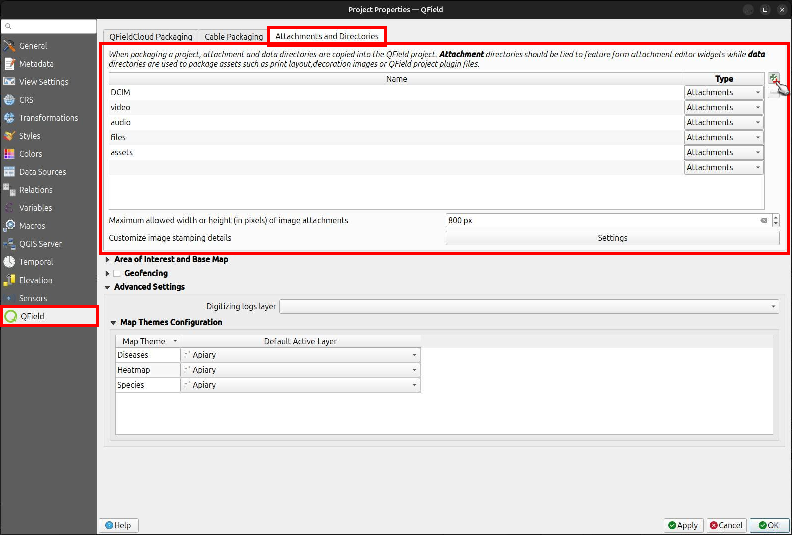
Configuration of Attachment Folders
If your project contains photos, documents or other attachments, you have to configure your QGIS project accordingly to ensure that the data are downloaded to your QField device.
- In QGIS navigate to Project > Properties… > QField.
- Add your folder’s path to the “Attachments and Directories” list.
The path you enter must be relative to the location of your project file.
Example
You used pictures for a specific symbology.
These are stored in a folder named “assets” located inside your project home folder.
Add them under the folder name to the list.
Connect to a custom QFieldCloud server in QField and QFieldSync
QField and QFieldSync connect to the QFieldCloud service app.qfield.cloud by default.
You can modify the default that QField and QFieldSync connect to:
- Open the login screen in QField or QFieldSync.
- Double-tap on the Nyuki icon (the QFieldCloud logo).
- This action will reveal a field where you can enter the preferred QFieldCloud server address.
- Enter the details of the desired server in the provided field.
(Leaving the field empty will automatically connect to the default QFieldCloud server)
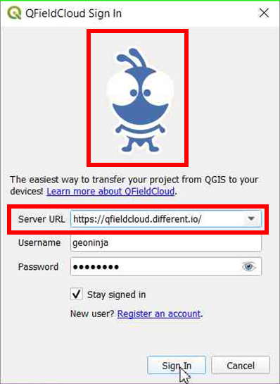
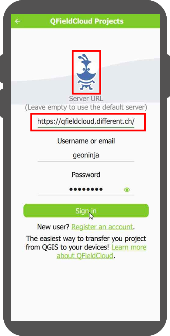
Note
QField will remember the last entered URL for future sessions.
It’s important to note that QFieldSync does not support the same cloud project in multiple QGIS profiles.
As a recommendation use a single QGIS profile for your QFieldCloud projects to avoid Synchronisation issues.
Related Articles
Advanced itinerary
The original version of this document is located at at https://docs.qfield.org/how-to/itinerary Advanced Itinerary This feature is used to inspect a list of objects that match a certain criteria. You may then navigate through these features with ...Authentication
The original version of this document is located at https://docs.qfield.org/how-to/advanced-how-tos/authentication Authentication QField supports connecting to services requiring access authentication. This page will go through authentication ...Get started with QFieldCloud
The original version of this document is located at https://docs.qfield.org/get-started/tutorials/get-started-qfc Get started with QFieldCloud What is QFieldCloud QFieldCloud is the cloud service that allows smoothless synchronisation of your data ...Multilingual project support
The original version of this document is located at https://docs.qfield.org/how-to/advanced-how-tos/multilingual-projects Multilingual Project Support in QField QField supports for Project Localization, meaning that a single QGIS project file ...PostgreSQL databases
The original version of this document is located at https://docs.qfield.org/how-to/project-setup/pg-service Working with PostgreSQL PostgreSQL in QField Working with databases can be much easier when working in a multi-user environment or when ...